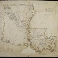
Louisiana
Dublin Core
Title
Louisiana
Subject
Louisiana
Description
Relief shown by hachures.
Shows waterways, towns, military posts.
Great detail shown around mouth of the Mississippi, in contrast to largely blank southwestern part of the state.
Outline color around the state.
Prime meridians: Philadelphia and London.
Shows waterways, towns, military posts.
Great detail shown around mouth of the Mississippi, in contrast to largely blank southwestern part of the state.
Outline color around the state.
Prime meridians: Philadelphia and London.
Creator
Carey,Mathew
Date
1818
Rights
There are no restrictions on
access.,The images in this database may be used for
non-commercial educational or research purposes. If you use or reproduce our materials in any
format, we ask that the Lilly Library always be cited as the source of the material with the
credit line: Courtesy, The Lilly Library, Indiana University, Bloomington, Indiana. For
commercial uses, please contact the Lilly Library at 1200 East Seventh Street, Bloomington,
Indiana, 47405-5500.
Format
1 map : hand col. ; 38 x 43 cm.
Type
Maps
Identifier
http://purl.dlib.indiana.edu/iudl/lilly/VAC2587/VAC2587-00011
Coverage
Louisiana,W0940000 W0890000 N0330000 N0290000
Collection
Citation
Carey,Mathew, “Louisiana,” The War of 1812 in the Collections of the Lilly Library, accessed May 4, 2024, https://collections.libraries.indiana.edu/warof1812/items/show/2885.


