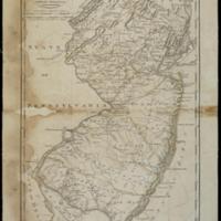
State of New Jersey
Dublin Core
Title
State of New Jersey
Subject
New Jersey--Administrative and political divisions::Chron., U.S.: Pennsylvania, 1815
Description
Relief shown pictorially.
Prime meridian: Philadelphia.
Map shows waterways, swamps, marshes, and shoals. Also shows roads, two classes of towns, rural landmarks (mills, churches, and taverns), county boundaries, and the "Division line of East and West Jersey."
Carlucci suggests 1814 to 1816 for date.
Digital image of 1814 ed. map in David Rumsey Historical Map Collection shows different coloring scheme.
Creator
Lewis,Samuel
Date
1815
Rights
There are no restrictions on
access.,The images in this database may be used for
non-commercial educational or research purposes. If you use or reproduce our materials in any
format, we ask that the Lilly Library always be cited as the source of the material with the
credit line: Courtesy, The Lilly Library, Indiana University, Bloomington, Indiana. For
commercial uses, please contact the Lilly Library at 1200 East Seventh Street, Bloomington,
Indiana, 47405-5500.
Format
1 map : hand col. ; 47 x 35 cm.
Type
Maps
Identifier
http://purl.dlib.indiana.edu/iudl/lilly/VAC2587/VAC2587-00012
Coverage
New Jersey--Administrative and political divisions,
Collection
Citation
Lewis,Samuel, “State of New Jersey,” The War of 1812 in the Collections of the Lilly Library, accessed May 3, 2024, https://collections.libraries.indiana.edu/warof1812/items/show/2886.


