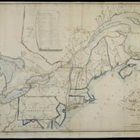
Map of the seat of war in North America
Dublin Core
Title
Map of the seat of war in North America
Subject
Canada::United States--History--War of 1812::Northeastern States::Chron., U.S.: Pennsylvania, 1813
Description
"NB. The figures along the roads denote the distance - thus 38 from Somerset to Bedford 38 mile."
Prime meridians: London and Washington.
Includes population table.
Map shows waterways, two classes of towns, roads, and distances.
Map also shows Virginia, Ohio, Indiana Territory, Michigan Territory.
Prime meridians: London and Washington.
Includes population table.
Map shows waterways, two classes of towns, roads, and distances.
Map also shows Virginia, Ohio, Indiana Territory, Michigan Territory.
Creator
Melish,John
Date
1813
Rights
There are no restrictions on
access.,The images in this database may be used for
non-commercial educational or research purposes. If you use or reproduce our materials in any
format, we ask that the Lilly Library always be cited as the source of the material with the
credit line: Courtesy, The Lilly Library, Indiana University, Bloomington, Indiana. For
commercial uses, please contact the Lilly Library at 1200 East Seventh Street, Bloomington,
Indiana, 47405-5500.
Format
1 map : hand col. ; 35 x 54 cm.
Type
Maps
Identifier
http://purl.dlib.indiana.edu/iudl/lilly/VAC2587/VAC2587-00010
Coverage
Canada,United States--History--War of 1812,Northeastern States,W0880000 W0580000 N0520000 N0390000
Collection
Citation
Melish,John, “Map of the seat of war in North America,” The War of 1812 in the Collections of the Lilly Library, accessed April 30, 2024, https://collections.libraries.indiana.edu/warof1812/items/show/2884.


