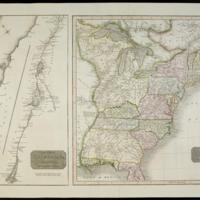
United States of America
Dublin Core
Title
United States of America
Subject
Canada::Saint Lawrence River::United States
Description
"J. & G. Menzies sculpt. Edinr."
Saint Lawrence map NE/SW orientated and shown in two sections split at Orleans Island.
Relief shown by hachures.
Shows state and provinical boundaries, waterways, principal settlements, locates Native American tribes.
Shows Old Northwest [including Ohio] as "The Western Territory," the area west of the Mississippi as Louisiana.
Saint Lawrence River ; United States east of the Mississippi River.
Date
1817
Rights
There are no restrictions on
access.,The images in this database may be used for
non-commercial educational or research purposes. If you use or reproduce our materials in any
format, we ask that the Lilly Library always be cited as the source of the material with the
credit line: Courtesy, The Lilly Library, Indiana University, Bloomington, Indiana. For
commercial uses, please contact the Lilly Library at 1200 East Seventh Street, Bloomington,
Indiana, 47405-5500.
Format
2 maps on 1 sheet : hand col. ; 42 x 23 cm. and 42 x 38 cm. on sheet 45 x 63 cm.
Type
Maps
Identifier
http://purl.dlib.indiana.edu/iudl/lilly/VAC2587/VAC2587-00015
Coverage
Canada,Saint Lawrence River,United States,W0940000 W0700000 N0480000 N0300000
Collection
Citation
“United States of America,” The War of 1812 in the Collections of the Lilly Library, accessed May 4, 2024, https://collections.libraries.indiana.edu/warof1812/items/show/2889.


