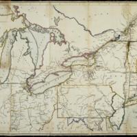
Correct map of the seat of war
Dublin Core
Title
Correct map of the seat of war
Subject
United States--History--War of 1812::Qu
Description
Shows drainage, state, provincial, and territorial boundaries, towns, roads with distances, and locations for some Native American tribes.
Shows "Road cut by Gen. Hull" and "Indian Boundary Line" [i.e. Treaty of Greenville boundary line, 1795].
Prime meridian: Philadelphia.
Shows "Road cut by Gen. Hull" and "Indian Boundary Line" [i.e. Treaty of Greenville boundary line, 1795].
Prime meridian: Philadelphia.
Creator
Lewis,Samuel
Date
1812
Rights
There are no restrictions on
access.,The images in this database may be used for
non-commercial educational or research purposes. If you use or reproduce our materials in any
format, we ask that the Lilly Library always be cited as the source of the material with the
credit line: Courtesy, The Lilly Library, Indiana University, Bloomington, Indiana. For
commercial uses, please contact the Lilly Library at 1200 East Seventh Street, Bloomington,
Indiana, 47405-5500.
Format
1 map : hand col., dissected and mounted on silk ; 38 x 57 cm.
Type
Maps
Identifier
http://purl.dlib.indiana.edu/iudl/lilly/VAC2587/VAC2587-00014
Coverage
United States--History--War of 1812,Qu
Collection
Citation
Lewis,Samuel, “Correct map of the seat of war,” The War of 1812 in the Collections of the Lilly Library, accessed May 3, 2024, https://collections.libraries.indiana.edu/warof1812/items/show/2888.


