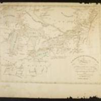
Map of Upper and Lower Canada and United States, contiguous, contiguous, contracted from the Manuscript surveys of P.F. Tardieu
Dublin Core
Title
Map of Upper and Lower Canada and United States, contiguous, contiguous, contracted from the Manuscript surveys of P.F. Tardieu
Subject
Maps::Canada--Maps::Indiana--Maps::Ohio--Maps::United States--Maps::Kensett, Thomas, 1786-1829::Tardieu, P. F.
Description
This Map of Upper and Lower Canada and United States, contiguous, contiguous, contracted from the Manuscript surveys of P.F. Tardieu, is respectfully inscribed by the public
Creator
Kensett,Thomas,1786-1829
Source
War of 1812 mss., 1776-1879--http://purl.dlib.indiana.edu/iudl/findingaids/lilly/InU-Li-VAC1213
Rights
This collection is open for research.
Format
Folio. Autographed map. 35 x 46 cm.
Language
eng
Type
Text
Identifier
http://purl.dlib.indiana.edu/iudl/lilly/VAC1213-02402
Coverage
Canada--Maps,Indiana--Maps,Ohio--Maps,United States--Maps
Citation
Kensett,Thomas,1786-1829, “Map of Upper and Lower Canada and United States, contiguous, contiguous, contracted from the Manuscript surveys of P.F. Tardieu,” The War of 1812 in the Collections of the Lilly Library, accessed May 17, 2024, https://collections.libraries.indiana.edu/warof1812/items/show/2381.


